
Category:United Kingdom photographs taken on 2007-10-10
| ← | Wednesday 10 October 2007 | → | ||
| ← | October 2007 | → | ||

United Kingdom photographs taken on 10 October 2007.
Image files should be categorized here automatically using {{taken on}} template. Direct categorisation is also possible, if automatic is impossible.
Subcategories
This category has the following 2 subcategories, out of 2 total.
Media in category "United Kingdom photographs taken on 2007-10-10"
The following 200 files are in this category, out of 830 total.
(previous page) (next page)-
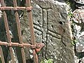 2nd Gatepost Cross at Llanllawer Church - geograph.org.uk - 946950.jpg 640 × 480; 108 KB
-
 A flock of geese preparing to land - geograph.org.uk - 581371.jpg 640 × 480; 50 KB
-
 A Holiday View - geograph.org.uk - 580867.jpg 640 × 405; 73 KB
-
 A large grazing field at Darnick - geograph.org.uk - 582058.jpg 640 × 480; 117 KB
-
-
 A view from an Aberystwyth car park - geograph.org.uk - 584783.jpg 640 × 480; 67 KB
-
 A1123 east of Wicken - geograph.org.uk - 581556.jpg 640 × 480; 87 KB
-
 A1123 heading west into Wilburton - geograph.org.uk - 581575.jpg 640 × 468; 104 KB
-
 Access road to Hardgate - geograph.org.uk - 581733.jpg 640 × 480; 141 KB
-
 Access to Blackhall - geograph.org.uk - 581705.jpg 640 × 480; 140 KB
-
 Access to North Tillydaff - geograph.org.uk - 580861.jpg 640 × 480; 135 KB
-
 Acer leaves in Chatsworth Park - geograph.org.uk - 582443.jpg 640 × 421; 245 KB
-
 Acers in Chatsworth Park - geograph.org.uk - 582438.jpg 640 × 383; 196 KB
-
 Acers in the early evening at Chatsworth - geograph.org.uk - 582448.jpg 497 × 640; 251 KB
-
 Across the Llyfnant Bridge - geograph.org.uk - 580991.jpg 640 × 480; 91 KB
-
_from_Maginnis_Bridge_-_geograph.org.uk_-_582593.jpg/120px-Afon_Hafren_(River_Severn)_from_Maginnis_Bridge_-_geograph.org.uk_-_582593.jpg)
-
 Afon Llyfnant.jpg 640 × 480; 86 KB
-
 Agricultural land east of Loch Leven - geograph.org.uk - 582082.jpg 640 × 424; 47 KB
-
 All Saint's Church, Buttington - geograph.org.uk - 580916.jpg 640 × 480; 102 KB
-
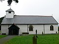 All Saints Church, Buttington - geograph.org.uk - 580908.jpg 640 × 480; 79 KB
-
 All Saints Church, Middletown - geograph.org.uk - 582897.jpg 473 × 640; 94 KB
-
 All Saints Church, Newmarket - geograph.org.uk - 581547.jpg 640 × 451; 75 KB
-
 All Saints Road, Newmarket - geograph.org.uk - 581549.jpg 640 × 464; 79 KB
-
 All Saints, Buttington - geograph.org.uk - 580918.jpg 480 × 640; 73 KB
-
 Anchors away - geograph.org.uk - 581769.jpg 640 × 480; 98 KB
-
 Ancient Shed - geograph.org.uk - 580801.jpg 640 × 615; 177 KB
-

-
 Another Hawkish Flower - geograph.org.uk - 580995.jpg 640 × 608; 266 KB
-

-
 Aqueduct and Viaduct at Chirk - geograph.org.uk - 583057.jpg 640 × 480; 140 KB
-
 Arable land in front of Hassop Hall - geograph.org.uk - 583515.jpg 640 × 430; 92 KB
-
 Arrival at Aberystwyth - geograph.org.uk - 580828.jpg 640 × 480; 88 KB
-
 Ash Spring Wood, Drax - geograph.org.uk - 584449.jpg 480 × 640; 101 KB
-
 Autumn lane - geograph.org.uk - 581215.jpg 480 × 640; 170 KB
-
 Autumn view on The Mall East, Armagh - geograph.org.uk - 581051.jpg 640 × 480; 127 KB
-

-
 Ballybrannon Road, Armagh. - geograph.org.uk - 580977.jpg 640 × 480; 71 KB
-
 Bangor Marina at dusk - geograph.org.uk - 585357.jpg 640 × 480; 60 KB
-
 Barlow Common, Camblesforth - geograph.org.uk - 584555.jpg 640 × 495; 183 KB
-
_-_geograph.org.uk_-_582044.jpg/120px-Barton_Stacey_-_The_Fruits_of_Autumn_(2)_-_geograph.org.uk_-_582044.jpg) Barton Stacey - The Fruits of Autumn (2) - geograph.org.uk - 582044.jpg 640 × 512; 106 KB
Barton Stacey - The Fruits of Autumn (2) - geograph.org.uk - 582044.jpg 640 × 512; 106 KB
-
_-_geograph.org.uk_-_581131.jpg/120px-Bell_Heather_(Erica_cinerea)_-_geograph.org.uk_-_581131.jpg) Bell Heather (Erica cinerea) - geograph.org.uk - 581131.jpg 640 × 386; 188 KB
Bell Heather (Erica cinerea) - geograph.org.uk - 581131.jpg 640 × 386; 188 KB
-
 Benington Ings - geograph.org.uk - 581139.jpg 640 × 427; 60 KB
-
 Big fields at Hempriggs - geograph.org.uk - 582920.jpg 640 × 425; 153 KB
-
 Bingley Baptist Church - Park Road - geograph.org.uk - 581486.jpg 460 × 640; 25 KB
-
 Bingley Court House - Main Street - geograph.org.uk - 581493.jpg 640 × 379; 35 KB
-
 Bingley Hospital - Fernbank Drive - geograph.org.uk - 581564.jpg 640 × 442; 38 KB
-
 Bingley Police Station - Main Street - geograph.org.uk - 581492.jpg 640 × 398; 33 KB
-

-
 Blackhall - geograph.org.uk - 581714.jpg 640 × 480; 134 KB
-
-
 Blackisland Road, towards Armagh. - geograph.org.uk - 580946.jpg 640 × 480; 79 KB
-
 Blaze Fell - geograph.org.uk - 963160.jpg 640 × 425; 76 KB
-
 Bodysgallen hotel car park - geograph.org.uk - 581510.jpg 640 × 480; 129 KB
-
 Bracken - geograph.org.uk - 582884.jpg 640 × 425; 116 KB
-
 Branstone Crossroads - geograph.org.uk - 581269.jpg 640 × 480; 55 KB
-

-
 Bringing in the mussels - geograph.org.uk - 581498.jpg 640 × 422; 77 KB
-
 Brora beach - geograph.org.uk - 583048.jpg 640 × 426; 86 KB
-
 Building at the entrance to Hassop Hall - geograph.org.uk - 583502.jpg 640 × 428; 215 KB
-
 Buildings close to manor house, Wilburton - geograph.org.uk - 581572.jpg 640 × 480; 103 KB
-
 Bun an Loin, Loch Morar - geograph.org.uk - 869298.jpg 427 × 640; 91 KB
-
 Burnsall bridge in Wharfedale - geograph.org.uk - 1425535.jpg 640 × 480; 75 KB
-
 Buttington Cemetery - geograph.org.uk - 580921.jpg 640 × 480; 150 KB
-
 Buttington Old Hall - geograph.org.uk - 581021.jpg 640 × 480; 102 KB
-
 Caaf Reservoir - geograph.org.uk - 581919.jpg 640 × 480; 82 KB
-
 Caaf Reservoir - geograph.org.uk - 581924.jpg 466 × 640; 86 KB
-
 Caaf Reservoir - geograph.org.uk - 581936.jpg 480 × 640; 114 KB
-
 Caaf Water - geograph.org.uk - 581915.jpg 480 × 640; 167 KB
-
 Caaf Water Valley - geograph.org.uk - 581907.jpg 480 × 640; 105 KB
-
 Caaf Water Valley - geograph.org.uk - 581930.jpg 480 × 640; 118 KB
-
 Cambrian Sentinels - geograph.org.uk - 581103.jpg 640 × 480; 77 KB
-
 Camster Long Cairn - geograph.org.uk - 583066.jpg 640 × 425; 149 KB
-
-

-
 Carnbane Townland - geograph.org.uk - 582465.jpg 640 × 479; 77 KB
-
 Catholic church in Hassop - geograph.org.uk - 583495.jpg 640 × 428; 192 KB
-
 Cheddleton Station - geograph.org.uk - 582386.jpg 640 × 480; 44 KB
-
 Chirk Aqueduct and valley - geograph.org.uk - 581401.jpg 640 × 202; 53 KB
-
 Church Road from Northern Crescent - geograph.org.uk - 580875.jpg 640 × 416; 66 KB
-

-
 Civic Hall, Ellesmere Port - geograph.org.uk - 584600.jpg 630 × 472; 61 KB
-

-
 Clusters of Heather - geograph.org.uk - 581033.jpg 640 × 480; 77 KB
-
 Collas Hill - geograph.org.uk - 582176.jpg 640 × 479; 88 KB
-
 Colour throughout the Park - geograph.org.uk - 582461.jpg 640 × 388; 195 KB
-

-
 Commemorative plaque - geograph.org.uk - 582399.jpg 480 × 640; 89 KB
-
_-_geograph.org.uk_-_581118.jpg/120px-Common_Storksbill_(Erodium_cicutarium)_-_geograph.org.uk_-_581118.jpg) Common Storksbill (Erodium cicutarium) - geograph.org.uk - 581118.jpg 640 × 465; 243 KB
Common Storksbill (Erodium cicutarium) - geograph.org.uk - 581118.jpg 640 × 465; 243 KB
-
 Competition Scarecrow - geograph.org.uk - 580911.jpg 480 × 640; 65 KB
-
 Concrete road at Lisgorgan - geograph.org.uk - 582317.jpg 640 × 479; 48 KB
-
 Consall Station - geograph.org.uk - 582374.jpg 640 × 480; 71 KB
-
 Consallforge weir and sluices - geograph.org.uk - 582340.jpg 640 × 480; 76 KB
-
 Conwy boats - geograph.org.uk - 581495.jpg 640 × 257; 54 KB
-
 Conwy Castle - geograph.org.uk - 586941.jpg 480 × 640; 141 KB
-
 Conwy mussel sculpture - geograph.org.uk - 581502.jpg 640 × 480; 106 KB
-
 Cottage in Frampton Mansell - geograph.org.uk - 581145.jpg 640 × 480; 369 KB
-
 Cottages in Frampton Mansell - geograph.org.uk - 581147.jpg 640 × 479; 344 KB
-
-
 Cows at Tirnageeragh - geograph.org.uk - 582311.jpg 640 × 479; 67 KB
-
 Cross on Gatestone at Llanllawer - geograph.org.uk - 946946.jpg 640 × 480; 94 KB
-
 Crosskeys Townland - geograph.org.uk - 582315.jpg 640 × 479; 60 KB
-
 Culimore Close - East Wittering - geograph.org.uk - 580871.jpg 640 × 419; 93 KB
-
 Cullerlie stone circle - geograph.org.uk - 581621.jpg 640 × 480; 79 KB
-
-
 Cuthill House - geograph.org.uk - 582927.jpg 640 × 425; 148 KB
-
 Cwmbychan - geograph.org.uk - 581039.jpg 640 × 480; 86 KB
-
 Defending the brassicas - geograph.org.uk - 581315.jpg 640 × 427; 73 KB
-
 Churchyard Gate - geograph.org.uk - 588577.jpg 640 × 427; 98 KB
-
 Pillar Piscina - geograph.org.uk - 588596.jpg 427 × 640; 68 KB
-
 Departing from Dovey Junction - geograph.org.uk - 580835.jpg 640 × 480; 63 KB
-
 Derelict barn near Hassop - geograph.org.uk - 582490.jpg 640 × 428; 219 KB
-
 Derryhubbert Mission Hall, Portadown. - geograph.org.uk - 580960.jpg 640 × 480; 67 KB
-
 Detail of the Edgar Phillips Memorial - geograph.org.uk - 948919.jpg 489 × 640; 200 KB
-
_-_geograph.org.uk_-_581142.jpg/120px-Devil%27s_Bit_Scabious_(Succisa_pratensis)_-_geograph.org.uk_-_581142.jpg) Devil's Bit Scabious (Succisa pratensis) - geograph.org.uk - 581142.jpg 640 × 499; 242 KB
Devil's Bit Scabious (Succisa pratensis) - geograph.org.uk - 581142.jpg 640 × 499; 242 KB
-
 Dimonds Hill - geograph.org.uk - 582181.jpg 640 × 406; 44 KB
-
 Dire warnings in Brown's Coppice - geograph.org.uk - 582328.jpg 640 × 480; 121 KB
-
-
 Disused bridge over canal - geograph.org.uk - 581765.jpg 640 × 480; 91 KB
-
 Doorway - geograph.org.uk - 583694.jpg 459 × 638; 107 KB
-
 Dovey Junction - geograph.org.uk - 581046.jpg 640 × 480; 65 KB
-
 Dovey Junction station - geograph.org.uk - 581038.jpg 640 × 480; 61 KB
-

-
 Drax Power Station - geograph.org.uk - 582042.jpg 436 × 640; 86 KB
-
 Drax Power Station - geograph.org.uk - 584472.jpg 480 × 640; 55 KB
-
 Drax power station.jpg 640 × 457; 58 KB
-
 Drumard Road - geograph.org.uk - 582388.jpg 640 × 479; 48 KB
-
 Drumglass Townland - geograph.org.uk - 582379.jpg 640 × 479; 62 KB
-
 Drumglass Townland - geograph.org.uk - 582380.jpg 640 × 479; 55 KB
-
_near_Maerdy_Farm_-_geograph.org.uk_-_580910.jpg/120px-Dry_dairy_cows_(not_in_milk)_near_Maerdy_Farm_-_geograph.org.uk_-_580910.jpg)
-
 Dupin Milestone - geograph.org.uk - 711732.jpg 640 × 479; 152 KB
-
 East edge of Hillhead wood - geograph.org.uk - 580842.jpg 640 × 480; 89 KB
-
 East Runton High Street - geograph.org.uk - 952142.jpg 640 × 480; 72 KB
-
 East Runton, seen from the Gap - geograph.org.uk - 952140.jpg 640 × 480; 56 KB
-
 East Wittering Shopping Centre - geograph.org.uk - 580838.jpg 640 × 425; 87 KB
-
 Edendarragh Townland - geograph.org.uk - 582477.jpg 640 × 479; 81 KB
-
 Edendarragh Townland - geograph.org.uk - 582478.jpg 640 × 479; 71 KB
-
 Edward VIII Postbox, Tobermory - geograph.org.uk - 607493.jpg 683 × 1,024; 148 KB
-
 Eggers - geograph.org.uk - 581006.jpg 640 × 425; 73 KB
-
 Eilean a' Chàr 660990.jpg 640 × 420; 138 KB
-
 Eldwick Methodist Church - Otley Road - geograph.org.uk - 581519.jpg 640 × 435; 40 KB
-

-
 Eldwick War Memorial - Otley Road - geograph.org.uk - 581523.jpg 584 × 640; 80 KB
-

-
 Ellesmere Port lighthouse - geograph.org.uk - 581767.jpg 467 × 640; 84 KB
-
 Encroaching Shingle - geograph.org.uk - 580892.jpg 640 × 413; 247 KB
-
 Humber Foreshore - geograph.org.uk - 581008.jpg 640 × 426; 92 KB
-

-
 Entrance to Northview Stud - geograph.org.uk - 580868.jpg 640 × 480; 76 KB
-
 EP Boat Museum.jpg 640 × 480; 224 KB
-
 Estate houses at Cefn - geograph.org.uk - 580938.jpg 640 × 480; 87 KB
-
 Excellent delicatessen - geograph.org.uk - 581529.jpg 640 × 480; 114 KB
-
 Farm at Mid Clyth - geograph.org.uk - 582919.jpg 640 × 425; 157 KB
-
 Farm at Tamnymullan - geograph.org.uk - 582482.jpg 640 × 479; 65 KB
-
 Farm Road - geograph.org.uk - 581879.jpg 640 × 424; 47 KB
-
 Farm Road - geograph.org.uk - 581894.jpg 640 × 424; 49 KB
-
 Farm road at Ashby Puerorum - geograph.org.uk - 581434.jpg 640 × 480; 85 KB
-
 Farm road leading east - geograph.org.uk - 581347.jpg 640 × 480; 49 KB
-
 Farmland - geograph.org.uk - 581369.jpg 640 × 424; 65 KB
-
 Fauld crater - geograph.org.uk - 582307.jpg 640 × 480; 68 KB
-
 Fauld Crater and memorial - geograph.org.uk - 582312.jpg 640 × 480; 71 KB
-
 Fauld explosion memorial - geograph.org.uk - 582298.jpg 640 × 480; 69 KB
-
 Fauld Memorial plaque - geograph.org.uk - 582299.jpg 639 × 480; 103 KB
-
 Fields near Hassop Hall - geograph.org.uk - 583514.jpg 640 × 430; 85 KB
-
 Final fence - geograph.org.uk - 663997.jpg 640 × 307; 61 KB
-
 Fleetwood Pier - geograph.org.uk - 1237422.jpg 640 × 427; 69 KB
-
 Fleetwood Pier - geograph.org.uk - 1237426.jpg 640 × 427; 39 KB
-
 Fleetwood Pier - geograph.org.uk - 1237430.jpg 640 × 427; 61 KB
-
 Fleetwood's Lower Lighthouse - geograph.org.uk - 1237433.jpg 427 × 640; 40 KB
-

-
 Flotsam Sculpture - geograph.org.uk - 581189.jpg 480 × 640; 47 KB
-
 Fly Agaric - geograph.org.uk - 581925.jpg 465 × 640; 115 KB
-

-
 Footbridge over The Montgomery Canal - geograph.org.uk - 581992.jpg 640 × 480; 156 KB
-

-
 Footpath in Brown's Coppice - geograph.org.uk - 582322.jpg 640 × 480; 113 KB
-

-
 Former Quarry - geograph.org.uk - 963099.jpg 640 × 425; 60 KB
-
 Former Wesleyan Chapel - geograph.org.uk - 581220.jpg 640 × 427; 65 KB
-
 Friskney - geograph.org.uk - 581296.jpg 640 × 427; 58 KB
-
 Froghall junction - geograph.org.uk - 582390.jpg 640 × 480; 76 KB
-
 Froghall Wharf - geograph.org.uk - 582405.jpg 640 × 480; 91 KB
-
 Fungi - geograph.org.uk - 581204.jpg 480 × 640; 114 KB
-

-

-

-
 Galashiels roofscape - geograph.org.uk - 582070.jpg 640 × 480; 121 KB
-
 Garden wall, Weasenham Hall - geograph.org.uk - 580821.jpg 640 × 480; 138 KB
-
 Garlogie Mill Power House.jpg 640 × 480; 102 KB
-
 Gated entrance to Dunecht estate - geograph.org.uk - 581274.jpg 640 × 480; 143 KB
-
 Gateway, Weasenham Hall - geograph.org.uk - 580810.jpg 640 × 480; 153 KB
-
 Geograph-588566-Dembleby-St Lucia church-by-Richard-Croft.jpg 640 × 427; 102 KB
-
 Geograph-588603-ScottWilloughby-by-Richard-Croft.jpg 640 × 427; 59 KB
-
 Goodbye Ethel - geograph.org.uk - 581766.jpg 640 × 401; 130 KB
-
 Field off Ferry Road, Goxhill - geograph.org.uk - 581074.jpg 640 × 412; 98 KB
-
 Flood Defence Wall at Goxhill Haven - geograph.org.uk - 770284.jpg 427 × 640; 89 KB
-
 Green Dragon Inn - geograph.org.uk - 580931.jpg 640 × 458; 63 KB
-
 Greenlough RC Church - geograph.org.uk - 582235.jpg 640 × 480; 44 KB
-

-
 Hackney Marshes.jpg 500 × 400; 113 KB
-
 Harvested field near Clashmore - geograph.org.uk - 582925.jpg 640 × 425; 145 KB


_from_Maginnis_Bridge_-_geograph.org.uk_-_582593.jpg)


_-_geograph.org.uk_-_582044.jpg)
_-_geograph.org.uk_-_581131.jpg)


_-_geograph.org.uk_-_581118.jpg)


_-_geograph.org.uk_-_581142.jpg)


_near_Maerdy_Farm_-_geograph.org.uk_-_580910.jpg)


